Floods! Has the weather gone wild?
“Rains that are almost biblical, heat waves that don’t end, tornadoes that strike in savage swarms—there’s been a change in the weather lately. What’s going on?” Peter Miller, National Geographic.
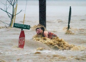
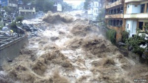
There’s been a change in the weather. “Extreme events like the Nashville flood—described by officials as a once-in-a-millennium occurrence—are happening more frequently than they used to. A month before Nashville, torrential downpours dumped 11 inches of rain on Rio de Janeiro in 24 hours, triggering mudslides that buried hundreds. About three months after Nashville, record rains in Pakistan caused flooding that affected more than 20 million people. In late 2011 floods in Thailand submerged hundreds of factories near Bangkok, creating a worldwide shortage of computer hard drives.
 Deadly heat waves have hit Europe, and record numbers of tornadoes have ripped across the United States. Losses from such events helped push the cost of weather disasters in 2011 to an estimated $150 billion worldwide, a roughly 25 percent jump from the previous year. In the U.S. last year a record 14 events caused a billion dollars or more of damage each, far exceeding the previous record of nine such disasters in 2008.
What’s going on? Are these extreme events signals of a dangerous, human-made shift in Earth’s climate? During an El Niño a giant pool of warm water that normally sits in the central Pacific surges east all the way to South America; during a La Niña it shrinks and retreats into the western Pacific. Heat and water vapor coming off the warm pool generate thunderstorms so powerful and towering that their influence extends out of the tropics to the jet streams that blow across the middle latitudes. As the warm pool shifts back and forth along the Equator, the wavy paths of the jet streams shift north and south—which changes the tracks that storms follow across the continents. An El Niño tends to push drenching storms over the southern U.S. and Peru while visiting drought and fire on Australia. In a La Niña the rains flood Australia and fail in the American Southwest and Texas—and in even more distant places like East Africa.”
Despite the US government previously asserting Climate Change was not something that was actually happening, the general consensus worldwide is now that global warming is a fact. As a result, the risk of flash flooding has increased due to a rise in the mean sea level and an increase in the incidence of extreme weather events are also now being recorded.
According to the Intergovernmental Panel on Climate Change’s (IPCC) Second Assessment on Climate Change 1995, the global sea level has risen between 10 and 25 cm in the past 100 years and much of the rise may be related to the increase in global mean temperature. The average sea level is projected to rise, mainly due to the thermal expansion of the oceans and the melting of glaciers and ice-sheets, 50 to 95 cm by 2100 and will continue to rise at the same rate beyond 2100, even if the concentrations of greenhouse gases and global mean temperatures are stabilized by that time.
At present, available data shows the Gulf Stream flow was stable over the past 40  years, although there is evidence that the deep return flow is weakening (according to one study even by 30% since 1957), which would imply a weakening in the North Atlantic Deep Water production. However, this should cause a temperature drop of a few degrees in North West Europe, which has not been observed. At least part of the apparent weakening of the Gulf Stream (if real) may be cyclical and connected to recent positive values of North Atlantic Oscillation. (The Climatic Research Unit has a detailed explanation of the North Atlantic Oscillation.)
A thermohaline circulation shutdown could have other major consequences apart from the cooling of Europe such as an increase in major floods and storms, the collapse of plankton stocks and the consequential impact on fish and marine mammals.
The optimists have hailed global warming as a chance to increase agricultural production, and barley is now a significant crop in Iceland whereas it was impossible to grow this crop 20 years ago. It seems likely that melting Arctic ice may open the Northwest Passage in summer, which would cut 5,000 nautical miles from shipping routes between Europe and Asia. This would be of particular relevance for supertankers that are too big to fit through the Panama Canal, but the melting of the sea ice is also likely to make the polar bear that does not hunt on land extinct in the near future. We have already seen the spread northwards of many species, but amongst the delights of new butterfly species, exotic fish in our seas and Little Egrets in our estuaries come some less than welcome immigrants such as malaria and other tropical diseases that are likely to establish themselves in the UK.
To develop improved estimates of flooding due to storm surges, and wetland losses due to accelerated sea-level rise, the work of Hoozemans et al. (1993) is extended to a dynamic analysis. It considers the effects of several simultaneously changing factors, including: global sea- level rise and subsidence; increasing coastal population. In all cases there is a global rise in sea level of about 38 cm from 1990 to the 2080s. Relative to an evolving reference scenario without sea-level rise, this analysis suggests that the number of people flooded by storm surge in a typical year will be more than five times higher due to sea-level rise by the 2080s. Many of these people will experience annual or more frequent flooding, suggesting that the increase in flood frequency will be more than nuisance level and some response (increased protection, migration, etc.) will be required. In absolute terms, the areas most vulnerable to flooding are the southern Mediterranean, Africa, and most particularly, South and South-east Asia where there is a concentration of low-lying populated deltas. However, the Caribbean, the Indian Ocean islands and the Pacific Ocean small islands may experience the largest relative increase in flood risk. By the 2080s, sea-level rise could cause the loss of up to 22% of the world’s coastal wetlands.
When combined with other losses due to direct human action, up to 70% of the world’s coastal wetlands could be lost by the 2080s. Therefore, sea-level rise would reinforce other adverse trends of wetland loss. The largest losses due to sea-level rise will be around the Mediterranean and Baltic and to a lesser extent on the Atlantic coast of Central and North America and the smaller islands of the Caribbean.
The process used to create this report and the Climate Change Effects Typology Matrix has resulted in a unique analysis of the best available climate projections. Some of the findings of this report are briefly outlined below.
- The Northeast is projected to become substantially warmer with an annual mean increase of 3.8 to 4.8°F, and wetter, particularly during the winter months. The duration of heavy precipitation events (i.e., more than 2 inches per day) is projected to increase along with the average amount of rain falling within a given rainy day.
- The Southeast is projected to undergo a 3.2 to 4.0°F increase in annual mean temperature, with greater warming and reduced precipitation during the summer and fall months.
- The Midwest is projected to experience an annual mean temperature increase of 4.0 to 5.0° F, with much wetter winters and springs and drier summers.
- The Great Plains’ annual mean temperature is projected to increase by 3.8 to 4.7°F, with wetter winters and drier summers.
- The Southwest is projected to experience an annual mean warming of 3.6 to 4.5°F, with summers and falls experiencing the greatest increases. The Southwest’s winters are projected to be somewhat wetter, while the spring months, in particular, are projected to be substantially drier.
- The Pacific Northwest is projected to experience an annual mean temperature increase of 3.6 to 4.3°F, with the greatest warming and greatest reductions in precipitation projected for the summer months.
- Alaska is projected to experience the greatest warming of any U.S. region, with increases in annual mean temperature of 4.3°F, and the greatest warming expected during the winter months. Precipitation increases are projected year round, ranging from 9 to 17%, depending on the season.
- Annual mean temperature on the Hawaiian Islands is projected to increase by 2.7 to 3.3°F. Hawaii’s precipitation is projected to increase during the fall months while the other seasons are projected to experience a decrease.
 In the coming years, model simulations of the effect of changes in greenhouse gas concentrations on the climate will improve, and downscaling techniques that provide finer-scale climate projections will continue to evolve.
Forecasters have confirmed what many suspected: summer 2012 in England and Wales has been the biggest washout for a century. The Met Office said it had been the one of the dullest on record, one of the coolest, and the soggiest since 1912.
As if to illustrate the point, Cumbria was hit by heavy rain and flash flooding on Thursday, forcing people to leave their homes and causing a train carrying about 100 passengers to derail. A landslide is thought to have caused the derailment of the two-carriage train, which was traveling towards Sellafield nuclear plant. No injuries were reported.
A deluge falls from the core of a thunderstorm near Glasgow in July 2010. “I felt like if you could stand in the middle and look up, you’d see straight into the heavens,” says photographer Sean Heavey, National Geographic.
Whether the floods experienced during the last decade in Germany and in other European countries are triggered or worsened by human activities has been the subject of a great deal of debate. Possible anthropogenic activities leading to increased flood risk include river regulation measures, intensified land use and forestry, and emissions of greenhouse gases causing a change in the global climate. Special consideration is given here to differences between the “typical” spatial scale of climate models and hydrological flood models. Second, observations of trends in climate variables relevant for river flooding issues are summarized. The “cascade of flood risk” is summarized, introducing the special features of meteorological, hydrological, and river hydraulic models.
Punctuating the sensationalism, and between the TV commercials from the oil, gas, coal and nuclear industries, are story after story of extreme weather events. Herein lies the real scandal: Why aren’t the TV meteorologists, with each story, following the words “extreme weather” with another two: “climate change”?
“We’re making the Earth a more dynamic and violent place … we’re trapping more of the sun’s energy in this narrow envelope of atmosphere, and that’s now expressing itself in many ways. We don’t know for sure that any particular tornado comes from climate change. There have always been tornadoes. We do know that we’re seeing epic levels of thunderstorm activity, of flooding, of drought, of all the things that climatologists have been warning us about.” Says : Amy Goodman
This is this week’s blog for GreenDustries. We are 100% earth friendly!
Visitors: 32755


No comments yet.