Mother Nature’s Monster Storm: Our Wake Up Call.
Global warming is making hot days hotter, rainfall and flooding heavier, hurricanes stronger and droughts more severe.
This intensification of weather and climate extremes will be the most visible impact of global warming in our everyday lives. People who have the least ability to cope with these changes–the poor, very old, very young, or sick–are the most vulnerable.
Stronger hurricanes, heavier rainfall and rising sea level: this is what global warming has in store for the U.S. Gulf and Atlantic coasts. The latest science indicates that maximum hurricane wind speed will increase 2 to 13 percent and rainfall rates will increase 10 to 31 percent over this century. At the same time, sea-level rise will cause bigger storm surges and further erode the natural defenses provided by coastal wetlands that buffer storm impacts.
Climate change did not cause Sandy. But it gave her a big shot in the arm and turned her into the beast that she became. Scientists say the devastating storm was super sized by climate change, fuelled by the same processes that will cause more extreme cyclones in Australia.
Professor Matthew England is chair of the Science Advisory Panel to the Australian Climate Commission, as well as being the joint director of the Climate Change Research Centre at the University of New South Wales. The Professor of Ocean Physics told news.com.au that as the oceans warmed due to greenhouse gas emissions they powered more intense storms, which has “direct relevance” for Australia. “Sandy derived its energy from the warmth of the ocean; and we’ve warmed the ocean via greenhouse gases so the world’s storms are being energised by climate change,” he said.
“With absolute certainty extreme heat events will increase in intensity and storms will get their energy from the warming oceans. It doesn’t mean every storm we get will be stronger … but we’ll see more of these devastating storms.”
“The evidence for the Australian region is less clear than the Atlantic but … the Coral Sea and the Indian Ocean, where we get tropical cyclones from, (have warmed) and they will without doubt increase the intensity of storms in Australia.”
Scientific bodies from NASA to the Intergovernmental Panel on Climate Change have predicted these increases in extreme weather events.
In general, hurricanes depend tremendously on the environment in which they form. In particular, they depend on the sea surface temperature. Since the 1970s, sea surface temperatures are higher because of climate change by about 1 degree Fahrenheit. The air above the ocean is warmer and moister as a result. Research shows that the water holding capacity of the atmosphere goes up by about 4 percent for a 1 degree rise in temperature.
There are fluctuations, from natural variability and day-to-day weather and El Nino events and things like that, but that’s the general background. So as a general result we expect storms will be more intense, and in particular the rainfall will be heavier as a consequence. The extra moisture in the atmosphere provides fuel for the storm. The estimate is that there is an increase of about 5 to 10 percent in precipitation associated with climate change and we have seen examples of that in the last year or so with Hurricane Irene last year and Hurricane Isaac this year, where the main story was all about the flooding. On top of that, the sea temperatures along the coast from the Carolinas up to Canada are warmer, as much as 5 degrees Fahrenheit above normal, but there are some extra elements that are helping to feed this storm and keep it alive.
“There has been a series of extreme weather incidents. That is not a political statement. That is a factual statement.” “Anyone who says there’s not a dramatic change in weather patterns, I think is denying reality.”
Meanwhile, New York Governor Andrew Cuomo and Mayor Michael Bloomberg said they were in no doubt that climate change was playing a role. Mr Cuomo said the US was “now having a 100-year flood every two years”. Increasing greenhouse gas concentrations will have many effects
Greenhouse gas concentrations in the atmosphere will continue to increase unless the billions of tons of our annual emissions decrease substantially.
Increased concentrations are expected to:
- Increase Earth’s average temperature;
- Influence the patterns and amounts of precipitation;
- Reduce ice and snow cover, as well as permafrost;
- Raise sea level;
- Increase the acidity of the oceans;
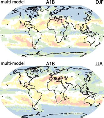
- Patterns of precipitation and storm events, including both rain and snowfall are also likely to change. The amount of rain falling in heavy precipitation events is likely to increase in most regions, while storm tracks are projected to shift poleward. Climate models project the following precipitation and storm changes.
 Global precipitation projections for December, January, and February (top map) and June, July, and August (bottom map.) Blue and green areas are projected to experience increases in precipitation by the end of the century, while yellow and pink areas are projected to experience decreases.
Source: Christensen et al. 2007
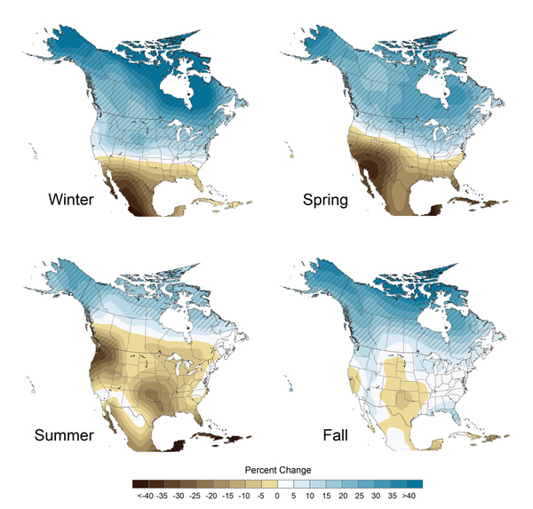
- Northern areas are projected to become wetter, especially in the winter and spring. Southern areas, especially in the West, are projected to become drier.
- Heavy precipitation events will likely be more frequent. Heavy downpours that currently occur about once every 20 years are projected to occur about every four to 15 years by 2100, depending on location.
- More precipitation is expected to fall as rain rather than snow, particularly in some northern areas.
- The intensity of Atlantic hurricanes is likely to increase as the ocean warms. Climate models project that for each 1.8°F increase in tropical sea surface temperatures the rainfall rates of hurricanes could increase by 6-18% and the wind speeds of the strongest hurricanes could increase by about 1-8%.
- Cold-season storm tracks are expected to continue to shift northward. The strongest cold-season storms are projected to become stronger and more frequent.
- Cold-season storm tracks are expected to continue to shift northward. The strongest cold-season storms are projected to become stronger and more frequent.
 The maps show projected future changes in precipitation relative to the recent past as simulated by 15 climate models. The simulations are for late this century, under a higher emissions scenario. For example, in the spring, climate models agree that northern areas are likely to get wetter and southern areas drier. There is less confidence in exactly where the transition between wetter and drier areas will occur. Confidence in the projected changes is highest in the areas marked with diagonal lines. Source: USGCRP 2009
“Climate science explains how global warming can make a superstorm like Sandy more destructive in several ways”, say Kevin Trenberth.
- Warming-driven sea level rise makes storm surges more destructive. In fact, a recent study found “The sea level on a stretch of the US Atlantic coast that features the cities of New York, Norfolk and Boston is rising up to four times faster than the global average.”
- “Owing to higher SSTs [sea surface temperatures] from human activities, the increased water vapor in the atmosphere leads to 5 to 10% more rainfall and increases the risk of flooding,” as Kevin Trenberth explained in a 2011 email about Hurricane Irene. He elaborates on that point for Sandy here and for all superstorms.
- “However, because water vapor and higher ocean temperatures help fuel the storm, it is likely to be more intense and bigger as well,” Trenberth added: Relatedly, warming also extends the range of warm SSTs, which can help sustain the strength of a hurricane as it steers on a northerly track into cooler water (much as apparently happened for Irene). September had the second highest global ocean temperatures on record and the Eastern seaboard was 5°F warmer .
- The unusual path of the storm — into the heavily populated east coast rather than out to see — was caused by a very strong blocking high pressure system that recent studies have linked to warming .
 Climate scientists and others have for quite some time been warning New York City that climate change was dramatically increasing the odds of a devastating storm surge — Says Greg Laden’s post.
And that’s the other key reason we must make the connection to climate change: Scientists worst-case scenarios are already happening. Now climate scientists project that we risk up to 10 times as much warming this century as in the last 50 years — with many devastating consequences from dramatic sea level rise to Dust-Bowlification .
“Climate-driven changes are already evident over the last few decades for severe thunderstorms, for heavy precipitation and flash flooding, for hurricane activity, and for heat-wave, drought and wildfire dynamics in parts of North America.”
You will think “what does GreenDustries have to do with it?” We at GreenDustries are aware of the situation that the world population is facing. Our products in the world fast food market, PleatPak and Magic Bag, will save 3,480,000 Metric tons of CO2, SO2, NOx each year. It will Prevent GREEN HOUSE GASES.


No comments yet.